Zoology
Zoology is the scientific study of animals, encompassing topics related to the biology, behaviour, structure, evolution, classification, and distribution of animals.
Zoology is the scientific study of animals, encompassing topics related to the biology,... View more
ArkLaTex Weather Outlook: Excessive Rainfall to Bring Flooding, Flash Flood Risk This Week
-
ArkLaTex Weather Outlook: Excessive Rainfall to Bring Flooding, Flash Flood Risk This Week
Excessive rainfall is likely in the ArkLaTex region this week, according to a weather report by the National Weather Service (NWS) for June 5 to June 7. Travelers should watch out for the challenging weather outlook in the region due to the slippery commute potential.
In nearby areas, thunderstorm conditions and excessive rainfall are likely from the Southern Plains to the Northeast this late week. People in low-lying areas are the most vulnerable to small to severe flooding, and it is best to be alerted to changing weather conditions.
Meanwhile, the forecast monitors the development of a pair of low-pressure systems in the eastern half of the country. These systems could potentially bring showers and thunderstorms to the East Coast.
In the ArkLaTex region, residents can anticipate rounds of rain this week, causing wet road conditions. People with travel plans should monitor the road outlook before traveling.
Weather in the ArkaLaTex region

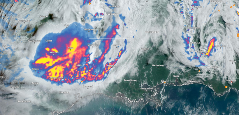
Zoom Earth Satellite via NOAA – NESDIS. The latest weather report shows that excessive rainfall is likely in the ArkLaTex region this week, leading to flash flood risk and flooding. (Photo : Zoom Earth Satellite via NOAA – NESDIS) According to a weather report, portions of Arkansas can anticipate rain and storm chances this week while mild temperatures continue. In eastern Arkansas, a storm redevelopment can occur, bringing rounds of rain.
The heavy rain potential can lead to flooding risks in the region. The forecast monitors possible strong storms moving into Arkansas. Homeowners can also anticipate winds up to 50 mph.
In addition, the forecast shows that a complex of showers and thunderstorms could develop in Oklahoma. These will spread over southwest Arkansas on Wednesday, causing significant risks of localized flash flooding. However, the chance of a tornado is very low.
Meanwhile, NWS Austin / San Antonio noted an outflow from thunderstorms in central and northern Texas. Residents can expect rain chances, which also help bring cooler air to the region.
In addition, the report shows that partly cloudy conditions can unfold in the area. The forecast still warns of dangerous heat in the western and southern portions. People are advised to check for Excessive Heat Warnings and Heat Advisories.
Also Read: 2024 Hurricane Season: Intense Storms Expected in Gulf of Mexico, Caribbean This Year
Weather in the Eastern US this week
On the East, commuters can experience soaking storms this week, bringing potential flash floods and flooding risks. On Wednesday, widespread rain and thunderstorms are likely in the following areas:
- Detroit
- Buffalo
- Columbus
- Charleston
- Washington
- Virginia Beach
- Burlington
- Portland
In New York, the advisory shows that morning low clouds and fog can unfold in the region. There is also a high pressure off the New England coast, which will help with the sunny and fair weather conditions.
On Thursday, wet weather could occur in Boston, New York, Pittsburgh, Raleigh, Jacksonville, and Green Bay. However, the late week is expected to become cooler in some parts of the Eastern US.
Related Article: Eastern US Weather Forecast: Heavy Rains, Gusty Winds to Bring Slow Travel, Flooding Concerns
For more similar stories, don’t forget to follow Nature World News.
© 2024 NatureWorldNews.com All rights reserved. Do not reproduce without permission.
Sorry, there were no replies found.
Log in to reply.
