GCSE
Geography
-
Introduction to GCSE Geography (AQA) -
1.1 The Challenge of Natural Hazards -
1.1.1 Natural Hazards -
1.1.2 Tectonic Hazards -
1.1.3 Effects of and Responses to Tectonic Hazards -
1.1.4 Reducing the Effects of Tectonic Hazards -
1.1.5 Global Atmospheric Circulation -
1.1.6 Tropical Storms -
1.1.7 Effects of Tropical Storms -
1.1.8 Weather Hazards in the UK -
1.1.9 Extreme Weather Events in the UK -
1.1.10 Climate Change -
1.1.11 Managing Climate Change
-
-
1.2 The Living World -
1.2.1 Ecosystems -
1.2.2 Tropical Rainforests -
1.2.3 Deforestation -
1.2.4 Sustainable Management of Tropical Rainforests -
1.2.5 Hot Deserts -
1.2.6 Development of Hot Desert Environments -
1.2.7 Desertification -
1.2.8 Cold Environments -
1.2.9 Development of Cold Environments -
1.2.10 Economic Development in Cold Environments
-
-
1.3 Physical Landscapes in the UK -
1.3.1 UK Physical Landscapes -
1.3.2 Coastal Landscapes -
1.3.3 Coastal Landforms -
1.3.4 Coastal Management -
1.3.5 River Landscapes -
1.3.6 Fluvial Landforms -
1.3.7 River Management -
1.3.8 Glacial Landscapes -
1.3.9 Formation of Glacial Landforms -
1.3.10 Economic Activities and Management Strategies in Glaciated Upland Areas
-
-
2.1 Urban Issues and Challenges -
2.2 The Changing Economic World -
2.3 The Challenge of Resource Management -
2.3.1 Food, Water and Energy -
2.3.2 Changing Demand and Provision of Resources in the UK -
2.3.3 Food: Food Resource Demand -
2.3.4 Food: Increasing Food Supply -
2.3.5 Water: Water Resource Demand -
2.3.6 Water: Increasing Water Supply -
2.3.7 Energy: Energy Resource Demand -
2.3.8 Energy: Increasing Energy Supply
-
-
3.1 Issue Evaluation -
3.2 Fieldwork -
4.1 Cartographic Skills -
4.2 Graphical Skills -
4.3 Numerical Skills -
4.4 Statistical Skills -
4.5 Use of Qualitative and Quantitative Data -
4.6 Formulate Enquiry and Argument -
4.7 Literacy
1. Living with the Physical Environment
1.1.4 Reducing the Effects of Tectonic Hazards
If we know about the location and severity of natural disasters, why don’t we just live outside these areas? This lesson will explore why people continue to live, despite the risk and how monitoring, prediction, protection, and planning can help mitigate these risks.
Why Take the Risk?
Despite the risks associated with tectonic hazards, people often choose to live in areas prone to such events due to various factors:
- Historical and Cultural Reasons: Long-standing settlements and cultural ties to the region may influence people’s attachment to their homeland, even in hazardous areas. Furthermore, historical resilience and adaptation to past hazards may instil a sense of confidence in facing future events.
- Economic Opportunities: Hazard-prone areas may offer economic advantages such as fertile soils for farming, natural resources for mining, or proximity to trade routes, making them attractive for livelihoods and economic activities. Tourists also visit places like Iceland and Naples because of their tectonic activity. Finally, tectonic activity can also be harnessed for geothermal energy, giving countries cheap, renewable energy. There are also limited alternative options or economic constraints that may restrict people’s ability to relocate to safer areas.
- Lack of Awareness or Perception: Limited knowledge about the specific risks or the perception that the benefits outweigh the hazards may contribute to people’s decision to remain in risk areas. Also, inadequate information, educational campaigns, and risk communication efforts may hinder individuals’ understanding of the potential dangers.
These risks however can be mitigated through monitoring, prediction, protection, and planning.
Try to visualise these processes: imagine an earthquake happening and step through how monitoring, predicting, protecting, and planning can reduce damage.Tip
Monitoring
Monitoring systems, such as seismographs, tiltmeters/GPS, and satellite technology, can detect and measure the movements of tectonic plates, providing valuable data for early warning systems and hazard assessment.
Volcano monitoring networks can track changes in volcanic activity, including gas emissions, ground deformation, and seismicity, aiding in the prediction of eruptions.
Prediction
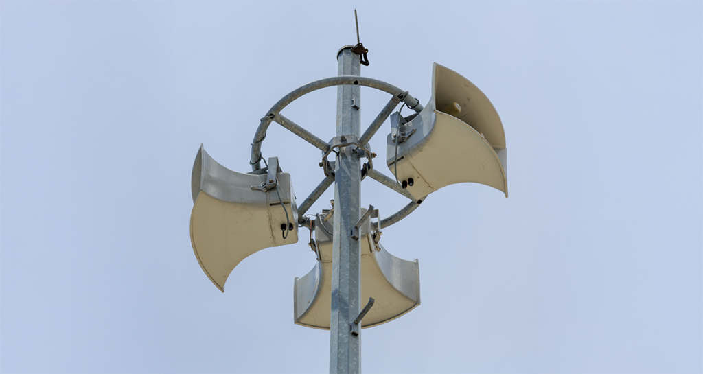
While it is challenging to predict precise timings and magnitudes of tectonic events, in particular earthquakes which can often give almost no warning, ongoing research and monitoring efforts contribute to improved forecasting capabilities. Early warning systems can provide vital seconds or minutes of advance notice before an earthquake or volcanic eruption, enabling evacuation and emergency preparedness.
Historical data analysis can also create trends to help us predict. For example, if an area that historically has earthquake activity on a 5-year basis, experiences no earthquakes within 5 years, we assume that one may be coming shortly.
Protection
Structural measures, such as designing earthquake-resistant buildings or implementing land-use planning regulations, can reduce the vulnerability of infrastructure and communities. LICs (Lower Income Countries) struggle to do this.
Students commonly write about preventing tectonic hazards. Always clarify that we can only reduce the effects, not stop the hazard itself.Common Mistake
Additionally, volcanic hazard mapping and the establishment of exclusion zones around active volcanoes can help protect people from pyroclastic flows, ashfall, and other volcanic hazards.
Planning
Effective disaster management plans and emergency response strategies are crucial for coordinated actions during and after a tectonic hazard event. Incorporating risk assessments, land-use planning, and zoning regulations into urban and regional planning processes can help steer development away from high-risk areas.
Use the acronym “PEBBLE” to remember key ways to reduce tectonic hazard impacts:Tip
Remember that protection and planning also includes the secondary effects of tectonic hazards, for example tsunamis or landslides.Common Mistake
Mexico and New Zealand practice community drills annually to keep earthquake preparedness fresh in people’s minds.Footnote